


ALL-TIME LOW — USGS gauge in Riverton shows rock-bottom water levels
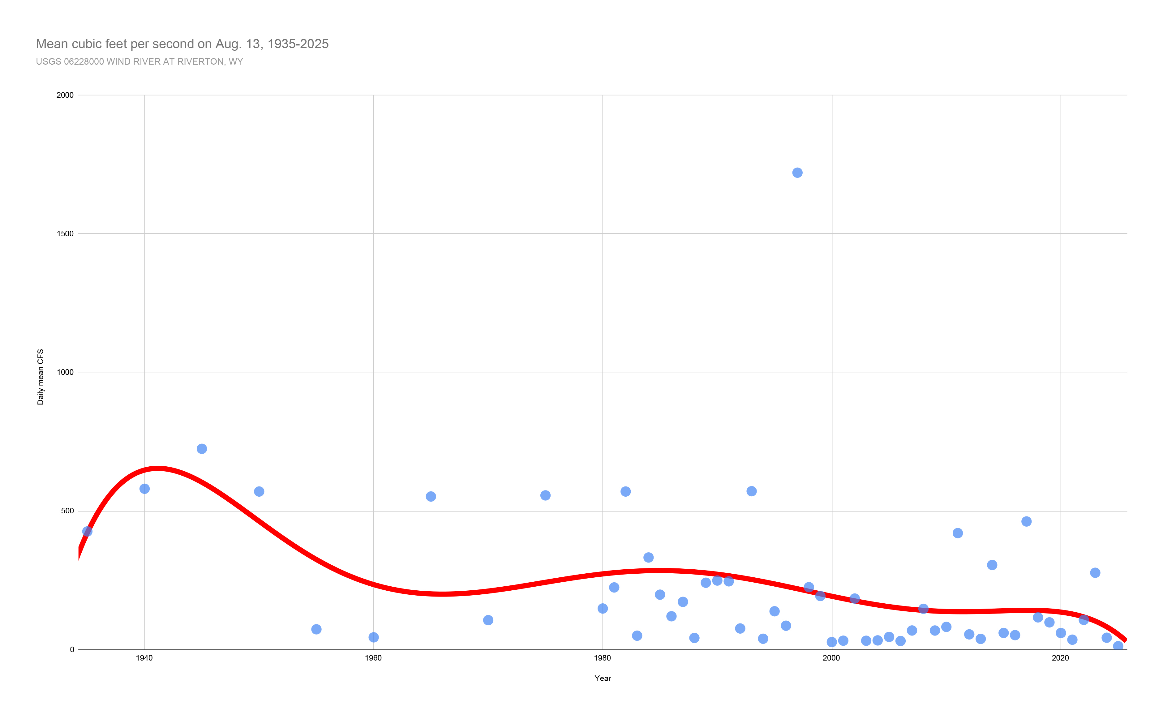
On August 13, the United States Geological Survey water gage at this location showed the river was at an all-time low for its period of record (1912-2025). Washakie Reservoir was constructed in 1934-35; the average discharge on August 13 from the time the dam was built until last year (1935-2024) comes out to 348 cubic feet per second. In 2025, the average discharge measured throughout the day of August 13 was 12.2 cubic feet per second; 2025 numbers are provisional.
On August 13, the United States Geological Survey water gage at this location showed the river was at an all-time low for its period of record (1912-2025). Washakie Reservoir was constructed in 1934-35; the average discharge on August 13 from the time the dam was built until last year (1935-2024) comes out to 348 cubic feet per second. In 2025, the average discharge measured throughout the day of August 13 was 12.2 cubic feet per second; 2025 numbers are provisional.
Winding down out of the Rocky Mountains, the Wind River is an important source of water for people, agriculture, and recreation from its headwaters past where its name changes all the way to where it joins the Yellowstone River as its largest tributary. Normally in August, the river is running at around 340 cubic feet per second (CFS); Wednesday, the United States Geological Survey National Water Dashboard showed its gauge at Riverton as a bright scarlet dot. At an average discharge of just 12.2 CFS, the Wind River at Riverton was at an all-time low for that day. It continued to stay at all time low flows on Thursday and into Friday morning.
The U.S. Drought Monitor places most of Fremont County at abnormally dry or moderate drought conditions as of August 12. But the Wind River Water Resource Control Board (WRWRCB) places the region's drought condition at a D4. "This is the most severe drought classification and signals exceptional drought conditions across our region," a public notice from the WRWRCB reads.
According to Tribal Water Engineer Baptiste Weed, different board members live in different parts of the Wind River Reservation – meaning that when they all offer their different perspectives, it's a fairly representative view of what's going on with water across the reservation. With low snowpack levels, in January the board put into place a "soft" D4 status; with spring runoff yet to come, the board members knew that water levels would rise in the spring and early summer, but anticipated it dropping off. As of July, that's been updated to a standard D4, and the office of the tribal water engineer is warning of potential water shortages that could impact irrigators and allocations.
In the Riverton area, some irrigation districts have already started low-water ditch rotations. The LeClair Irrigation District posted an announcement on its website explaining: "Several open ditch delivery systems which mainly service less than five acres, yards and gardens will be on rotation and shut off for a week to two weeks at a time. If we can get these headgates back on sooner we will. Large scale laterals have already been put on rotation and the usage amount cut. We will be or already have contacted water masters under such headgates to communicate to the many users who have never ordered water."
USGS data from the water gauge in the Wind River at Riverton (USGS gage 06228000) goes back to the early 1900s; the first August recorded was in 1912. Taking August 13 as an example, the data can be graphed and compared based on where the river stood on that day each year.
Across the entire period of record for that gauge, the average discharge on August 13 was 602 cubic feet per second. However, the river was subsequently dammed above the gauge. With the construction of Washakie Reservoir in 1934-35, modern flow levels start to be seen. For the timeframe starting from Washakie Reservoir's construction to 2024, the average discharge on August 13 was 348 CFS. That's more than 335 CFS more than what was measured on August 13 of this year.
There is some margin for error in USGS numbers, and 2025 numbers are still considered provisional. The nature of streambeds and water flows means that the gauge has to be checked from time to time to ensure it's still measuring accurately, and numbers need to be double checked and verified before they are officially approved.
Low water years are nothing unusual, but in the time period from 1965 to present, the next-lowest measure for August 13 is 27 cubic feet per second, more than double the 12.2 CFS provisional measure from this year. (After 1965, The Ranger looked back in five-year increments, so it's possible there was a slightly lower year somewhere within that timespan. However, as the graph on A1 illustrates, the general trend over time has been decreasing flows in the Wind River at Riverton.) Barring any major problems with the gauge, it's unlikely that this year's number is off by more than 100%.
Gage 06228000 in the Wind River at Riverton was not the only USGS water gauge showing an all-time low this past week. And as of press time Friday morning, of the dozen or so USGS gauges in the Fremont County area, only the Muddy Creek gauge above Boysen Reservoir and the Big Sandy River gauge near Farson were at normal flows.
This year in May, Weed said, there was 75% or less of the average snowpack for that time of year. With little snow in the high mountains, the WRWRCB knew a dry summer was likely to follow. However, irrigators still wanted to be able to water crops and hayfields, and early summer flows out of Washakie Reservoir ended up not being cut too drastically. Now, the WRWRCB is encouraging its users to plan ahead and use water efficiently.
"We understand the inconvenience of this and the fact is we cannot control the low amount of water in the river. We will continue to work diligently to efficiently deliver what water we do have," the LeClair Irrigation District wrote. "With this being said we ask all users who are irrigating to use it conservatively and keep your neighbor in mind."
Conservation districts and the Natural Resource Conservation Service often have resources to offer that can help people improve the efficiency of their irrigation systems. The Lower Wind River Conservation District can be reached at 307-463-0636. The office of the tribal water engineer can be reached at 307-3326464. The NRCS can be reached at 307-856-7524.
"This is the most severe drought classification and signals exceptional drought conditions across our region."
Wind River Water Resource Control Board
This story was published on August 16, 2025.