


Wind, Snake, Bear rivers hit record low flows as Wyoming’s summer drought gains steam
FROM WYOFILE:
Snowpack isn’t what it used to be. Severe drought has set in for portions of western Wyoming river basins, even after decent snow years, due to factors exacerbated by climate change.
During last winter’s peak, the snowpack blanketing southern Yellowstone National Park — mountains and snowfields that feed the high reaches of the Snake River — was sitting pretty good.
“We were right near average,” said Jeremy Dalling, a civil engineer who leads water operations in the Upper Snake system for the Bureau of Reclamation.
Once April hit, however, so did a prolonged period of dryness now extending into July, with just 60% of normal precipitation. A lack of precipitation, low base flows in rivers and exceptionally poor soil moisture also made for rough conditions going into the winter of 2024-’25.
Squeezed by aridity on both ends, the Snake basin’s roughly 100% of average snowpack both melted off early and went into the ground instead of rivers and creeks.
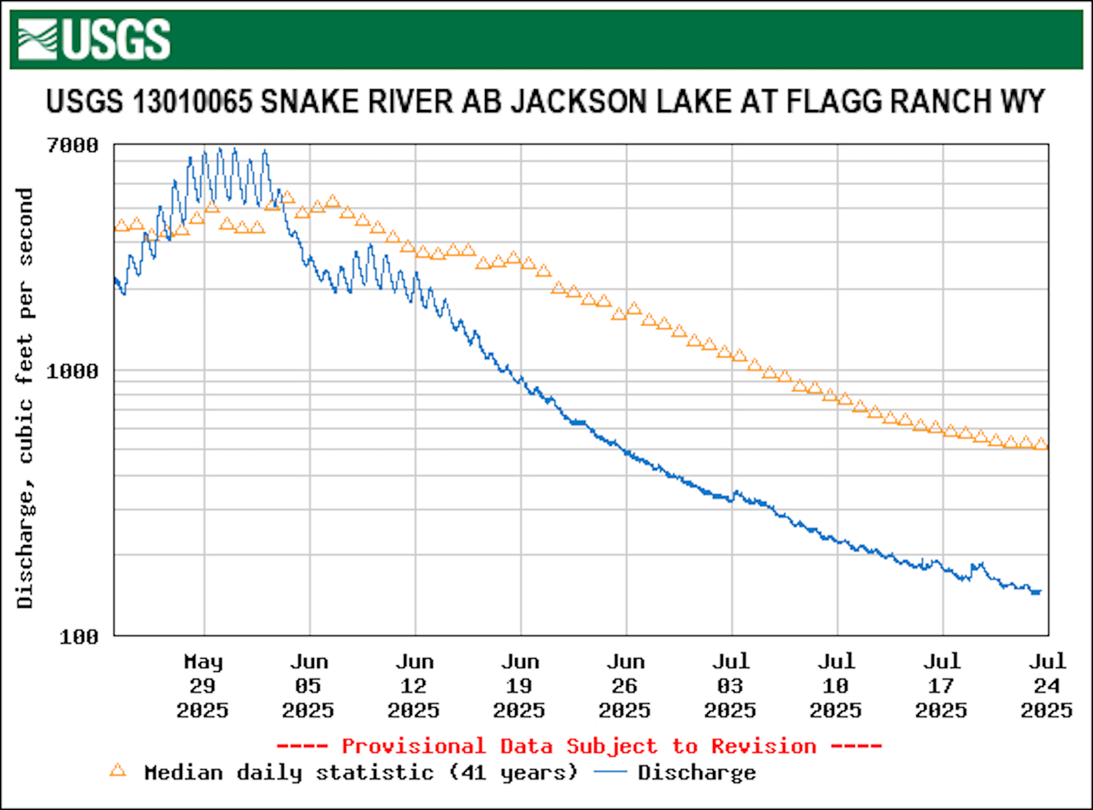
“It’s a compounding effect, actually over several years, that can lead up to this,” Dalling said, referring to record-low levels in the Snake River above Jackson Lake, even in the wake of a decent snow year.
As of Wednesday, the U.S. Geological Survey’s river gauge above Jackson Lake was detecting less water than it ever had before during the last week of July. Just 147 cubic feet per second — a relative trickle — were passing by the Flagg Ranch gauge. In 41 years of recordkeeping, that’s the lowest by a large margin. The previous minimum flow for July 23 was 263 CFS. This time of year, the typical flow coursing through the Flagg Ranch Canyon is 516 CFS, meaning the dismal dribble presently detected is only 28% of average.
“We’re experiencing August [river] levels in July, more or less,” Dalling said. “It’s a system-wide drought condition.”
The decent snowpack resulting in dismal or worse summer river flows is a dynamic that also carried over to the southern Rocky Mountains this year, said Jeff Lukas, a climate and water researcher who spent 20 years as a scientist with the University of Colorado-Boulder.
“Things just happened to look really good on April 1 this year and increasingly shitty after that,” Lukas said.
Reds, browns and yellows denoting record-low to below-average river flows also dominate Colorado’s USGS streamflow map.
Not all western Wyoming river reaches are running quite so thin in 2025. Counting all Teton Range tributaries, even Jackson Lake’s overall inflow isn’t the lowest on record, Dalling said. And lower down in the Snake, above where it hits Palisades Reservoir, the river flow on Wednesday was 3,870 CFS — a volume that sits in just the 5th percentile of flows for late July.
New record lows
But there are other western Wyoming river reaches running at new record lows, the USGS’ statewide monitoring shows. The Wind River near Kinnear on Wednesday was carrying 295 CFS, less volume than any other July 23 in 40 years of recordkeeping.
And the Bear River above Woodruff Narrows Reservoir is holding a pittance of water. Just 2 CFS were flowing Wednesday, a meager 7% of the median 31 CFS that have been detected over 63 years of data.
Like in the Upper Snake, those basins have been plagued by poor soil moisture. The thirsty soil is soaking up any precipitation at a rate that negates last winter’s decent snowpack and rainfall that’s come down.
“Soil moisture west of the divide — except for a couple holes — has been really pretty poor here for quite a while,” Wyoming State Climate Office Director Tony Bergatino told WyoFile.
It’s not all bad. Northeast Wyoming and the Bighorn Basin are faring well, modeling shows. But one of the maps that Bergatino monitors shows that modeled soil moisture in some regions of Wyoming is also bumping up against record low levels for late July.
“As you get down into the Green River Basin, and much of the state across the south, the [model] is showing basically zero to second percentile [soil moisture],” Bergatino said.
A different soil moisture map that models conditions with more precision is also registering near-record low readings, and it shows that the most dismal conditions are at the highest elevations.
Meanwhile, severe drought has set into portions of the Snake, Wind, Green and Bear river basins, according to the U.S. Drought Monitor.
A downstream disconnect
Lukas, the Colorado climate and water researcher, pointed out that the relationship between snowpack and river flows isn’t as solid as many think.
“If you have an 80% of normal snowpack … even if you have normal precipitation the rest of the runoff season, you’ll get a 60 to 70% of normal runoff,” he said. “Over the last 20 years, a 100% snowpack more often ends up at 90% [runoff].”
As the climate has warmed a few degrees over the last several decades, the divide has grown — and it’s expected to keep growing, Lukas said.
“Each degree of warming is going to give us less runoff for an equivalent amount of snowpack,” Lukas said.
“Climate change is part of the story,” he added. “There’s just a bunch of feedback mechanisms: The drying soil, the fact that vegetation can now germinate and grow earlier, the snow is melting out earlier, temperatures are warmer.”
For Dalling, at the Bureau of Reclamation, there are major implications from the dwindling river flows, which are widespread in the basin he manages.
“It’s impacting reservoir levels all across the Upper Snake reservoir system,” he said. “Jackson Lake is faring better than others, being as full as it is, but we’re monitoring it day to day for the remainder of the season.”
An almost complete draw-down year, like in 2021, isn’t looking necessary. But Jackson Lake, impounded by a 39-foot-high dam, figures to come down by quite a few feet.
“On the maximum end [of the projections] we’ll be 76% full in October,” Dalling said. “On the lower end, probably 65% full.”
The Snake’s spectacular cutthroat trout fishing is another factor that stands to suffer from the poor river flows, which have been joined by higher water temperatures.
In mid-June, Yellowstone National Park instituted some time-of-day fishing restrictions, prohibiting angling after 2 p.m. in the Madison, Firehole and Gibbon river watersheds. The Wyoming Game and Fish Department has not had to implement similar restrictions, but on Tuesday, the state agency sent out a public notice encouraging best practices for fishing in the heat. That guidance includes ceasing catch-and-release fishing anytime stream or river temperatures exceed 70 degrees — a threshold that can make the fight a lethal affair.
“Stream temperatures have been getting close to critical points on a number of tributaries of the Snake,” said Darren Rhea, Game and Fish’s Jackson Region fisheries supervisor.
That’s true on the Snake River itself, also.
Above Jackson Lake, where flows are the lowest on record, the thermometer on the Flagg Ranch gauge climbed up beyond 70 degrees on a handful of days so far in July.
WyoFile is an independent nonprofit news organization focused on Wyoming people, places and policy.
This story was posted on July 23, 2025.